Log in
All resources
Create a design
477 Free Artworks of Maps Antique
cartography
grabados
cartografía
cartografía, mapas | cartography, maps
illustration
17th century
fondo antiguo
engraving
plano
city
illustration
maps
illustration
maps
illustration
maps
illustration
maps
illustration
maps
illustration
maps
illustration
maps
illustration
maps
illustration
maps
illustration
maps
illustration
maps
illustration
maps
illustration
maps
illustration
maps
illustration
maps
illustration
maps
illustration
maps
illustration
maps
illustration
maps
illustration
maps
illustration
maps
illustration
maps
illustration
maps
illustration
maps
illustration
maps
illustration
maps
illustration
maps
illustration
maps
illustration
maps
illustration
maps
illustration
maps
illustration
maps
illustration
maps
illustration
maps
illustration
maps
historical collections of the state of new jersey (1845)
maps of burlington, new jersey
illustration
maps
illustration
maps
illustration
maps
illustration
maps
illustration
maps
illustration
maps
illustration
maps
illustration
maps
illustration
maps
illustration
maps
illustration
maps
illustration
maps
illustration
maps
illustration
maps
illustration
maps
illustration
maps
illustration
maps
illustration
maps
illustration
maps
burlington, new jersey in the 18th century
maps of burlington, new jersey
historical collections of the state of new jersey (1852)
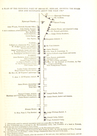
maps of newark, new jersey
illustration
maps
illustration
maps
illustration
maps
illustration
maps
illustration
maps
illustration
maps
illustration
maps
illustration
maps
bibliothèque nationale de france
guillaume sanson
the history and antiquities of london, westminster, southwark and parts adjacent
st martin outwich
history
maps
maps of paris from paris musées
baroque
cave of the drum-koba
moritz vebel
illustration
maps
historical collections of the state of new jersey (1852)
1850s maps of new jersey
map of the strait of kerch by guillaume sanson
bibliothèque nationale de france
recueil d'antiquités égyptiennes, étrusques, greques et romaines (1756)
historical images of paris
old maps of rome
antonio lafreri
maps of aachen by braun & hogenberg
bibliothèque nationale de france
illustration
maps
maps of ancient italy by philipp clüver
old maps of marche
illustration
maps
illustration
maps
illustration
maps
illustration
maps
illustration
maps
novopavlovka
moritz vebel
atlas des anciens plans de paris by imprimerie nationale, 1880 from bhvp
baroque
bibliothèque nationale de france
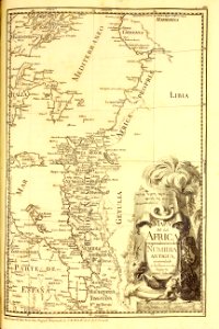
1667 sanson map of africa
bibliothèque nationale de france
guillaume sanson
bibliothèque nationale de france
guillaume sanson
illustration
maps
illustration
maps
illustration
maps
17th-century maps of the holy roman empire
maps by pieter van der keere
1667 sanson map of africa
1702 maps of africa
maps by jean-baptiste bourguignon d'anville
old maps of roman hispania
illustration
maps
illustration
maps
illustration
maps
illustration
maps
maps of brussels by braun & hogenberg
constantine and helena church (mangup)
moritz vebel
301 - 400 of 477
Next page
/ 5